4DAGE 4DKanKan Meta
Code Testoon : 4DA4DKanKanMeta
Caméra/Scanner 3D fixe et mobile - +-1/2 cm - portée 70m - 200000pt/s.
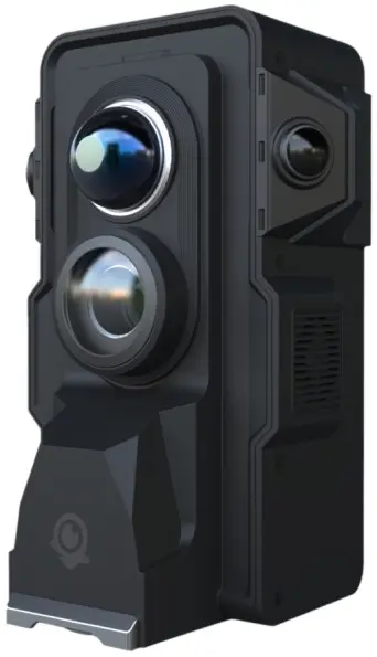
Caméra 3D avec Lidar (30 lasers).
Utilisable en fixe ou en mobile ("SLAM").
Vitesse d'acquisition : 200000 pts/s max.
Portée : 0.2 à 70m.
Précision : 1cm (fixe), 2cm (mobile).
Résolution caméra jusqu'à 16K,champ de vison 360°Hx320°V.
GPS, bluetooth, WiFi, mémoire 16Go interne.
Option Offline possible (nous consulter).
4DKanKan Meta
LiDAR Scanner (Usable as Terrestrial Laser and Wearable "SLAM")
Equipped with 905nm ultra-wide-angle fixed LiDAR and combined with the industry's leading point cloud fusion algorithms, produces high-precision point cloud data and 16K panoramas, supports terrestrial laser scanning and SLAM scanning.
- Terrestrial laser scanning + SLAM
- Multi-functional modules
- 16K high-definition panoramas
- Point cloud accuracy within ±1cm
- Dynamic point cloud coloring
- Fully automated data processing by algorithms
- Industry-specific softwares
- Privatization of information
Innovative modular design
LiDAR :
- 905nm LiDAR
- 200,000 points per second
- Scanning range up to 70m
Wide-angle Cameras :
- Produce true color point clouds
- Exposure metering in real time
Ultra-HD Camera :
- 1-inch super bottom CMOS
- 16K ultra-HD panoramas
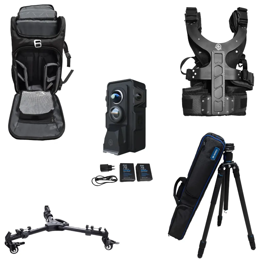
Multi-functional plugins (modules)
(sold separatly)
RTK
- Centimeter-level high-precision positioning based on GPS, GLONASS, GALILEO and BeiDou.
Thermal
- High-sensitivity temperature detector, temperature measurement accuracy of ± 2 ° C.
Fill Light
- Use fill light to work in dark environment, high brightness, low power consumption, improve work efficiency.
Multi-spectral
- Multi-spectral supports snapshot to capture multiple spectral bands at once and take multi-spectral images.
Fast reality capture and automatic data processing
Reality Capture
- Remote control from a mobile device, free selection of different capturing modes, one-touch data upload and automated processing.
Import Data into Surveying Software
- Support Autodesk series, CloudCompare, PCL and other professional softwares to create BIM and Building Lifecycle Management documents.
High-precision Measurement
- Flexible measurement tools, support accurate measurement of distance and area of space.
Space Tagging
- Add tags to any location in space, provide spatial information to digital twins.
Navigation
- Intelligent planning of indoor and outdoor routes, generate navigation routes automatically and accurately.
Votre snippet dynamique sera affiché ici...
Ce message s'affiche parce que vous n'avez pas défini le filtre et le modèle à utiliser.