![youtube - [Video]](/web/image/product.image/8948/image_128/youtube%20-%20%5BVideo%5D?unique=21cd65d)
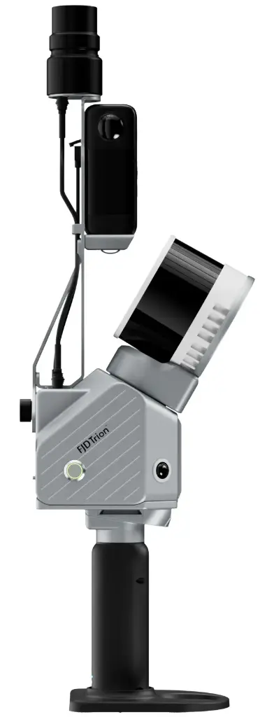
FJDynamics Trion S2

Scanner 3D LiDAR - 320-640000 pts/s - 1/3cm - avec caméra Insta360 X5
| Distance max (m) | 300m (S2Max) |
|---|---|
| Précision | 1-3 cm |
| Série | Trion S2 |
FJD TRION S2 SERIES
LiDAR Scanner
Smaller Size, Larger Capability
The FJD Trion S2 LIDAR Scanner boasts advanced VIO and SLAM algorithms for generating high-quality and reliable point clouds.
Supporting over 8000 coordinate systems, the S2 eliminates the need for time-consuming manual coordinate conversions.
By integrating with FJD Trion Scan and Model software and utilizing practical accessories like stabilizing vest, drone mount, car mount, and robot dog mount, the S2 enhances data capturing and processing efficiency for outdoor surveying projects.
Key Benefits
Multi-Module Integration
Integrate camera, IMU, and RTK modules into a compact form of 2kg in weight, allowing you to carry it around for various surveying projects.
Multi-SLAM Algorithms for Accurate Output
Embed two 12MP cameras to generate high-resolution images with advanced Visual-Inertial Odometry (VIO) and SLAM algorithms, delivering accurate results even in complex environments with fewer feature points.
Georeferenced Point Clouds
With an integrated RTK module, directly get georeferenced point clouds on the go. RTK & PPK support ensure accurate data collection in dense tree canopies and other signal-challenging areas. Plus, with over 8000 coordinate systems, no fear of tedious coordinate conversions anymore!
Designed to Work Together
Capture, process, and deliver your 3D data within one connected FJD Trion workflow.
Data Collection
FJD Trion Scan - App based real time control and scan file management.
Data Processing
FJD Trion Model - Generate reports for construction, forestry, mining, and more.
Generate Deliverables
FJD Trion Model for Tablets - On site post processing and preview with iPad and Android support.
Cloud Collaboration
FJD Trion Model Web - Share data online and collaborate with your team seamlessly
Specifications
Trion S2 |
Trion S2 Pro |
Trion S2 Max |
|
LiDAR |
|||
| Range | 120 m @ 80% reflectivity 80 m @ 10% reflectivity |
300 m @ 80% reflectivity 80 m @ 10% reflectivity |
|
| Channels | 16 | 32 | |
| Speed | 320 000 pts/s | 640 000 pts/s | |
| Safety Level | Eye Safety Class I (905nm) | ||
| FOV | 360° × 270° | ||
System Parameters |
|||
| Relative Accuracy | ≤1 cm | ||
| Absolute Accuracy | 3 cm | ||
| Weight | 1.8 kg (Excluding battery, external camera and GNSS module) | ||
| Battery Life | 3 h (with 1 set of 2 batteries) | ||
| Storage | 512 GB (1TB expandable) | ||
| Operating Temperature | -20℃ to 50℃ | ||
| Power Consumption | 25 W | ||
| Weight | 180g | ||
| Dimensions | 107 x 118 x 398 mm (including base and battery) | ||
| Data Export | Wi-Fi, USB Type-C, USB Flash Disk | ||
| Point Cloud Format | .las / .ply / .pts / .e57 | ||
| Power Supply | 10.8 V, 3 A | ||
Camera |
|||
| Resolution | 2 x 12 MP | ||
| FOV | 200° | ||
| Visual SLAM | ✓ | ||
| Image Export | ✓ | ||
| Image Format | .jpg | ||
| External Camera | Insta360 X5 | ||
GNSS |
|||
| Satellite Constellation | BDS: B1I / B2I / B3I / B1C / B2a / B2b GPS: L1 C/A / L1C / L2P (Y) / L2C / L5 GLONASS: G1 / G2 / G3 Galileo: E1 / E5a / E5b / E6 QZSS: L1C/A / L1C / L2C / L5 ( IRNSS and SBAS support by a firmware upgrade ) |
||
| GNSS Accuracy | H: 8 mm + 1 ppm RMS V: 15 mm + 1 ppm RMS |
||
| PPK | ✓ | ||