![youtube - [Video]](/web/image/product.image/8915/image_128/youtube%20-%20%5BVideo%5D?unique=9d96f65)
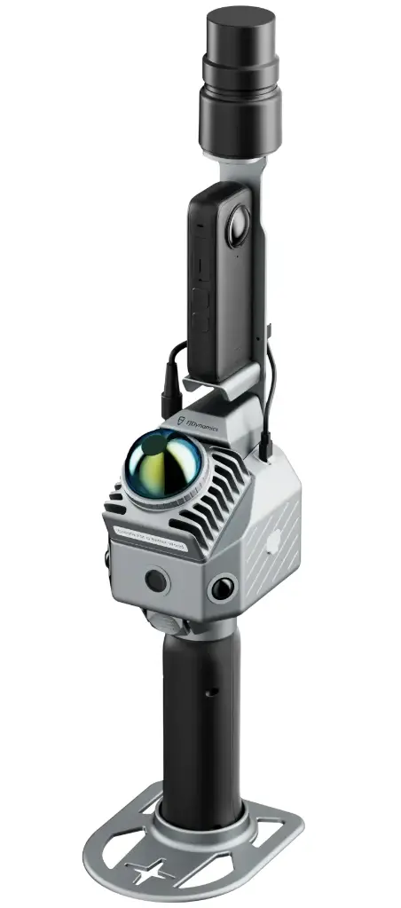
FJDynamics FJD Trion™ P2-x5

Scanner 3D LiDAR - 200000 pts/s - 2/5cm - avec caméra Insta360 X5
Très léger, le scanner LiDAR FJD Trion P2 offre une précision au centimètre près, des nuages de points colorisés en temps réel et des sorties multiformats. Grâce à sa conception adaptée au terrain, les professionnels peuvent capturer sans difficulté des paysages complexes et des détails minutieux.
Fusion Multi-SLAM, performances robustes.
Capturez, traitez et diffusez vos données 3D au sein d'un flux de travail FJD Trion intégré.
Double caméra 12MP + 1 camera 2MP intégrées.
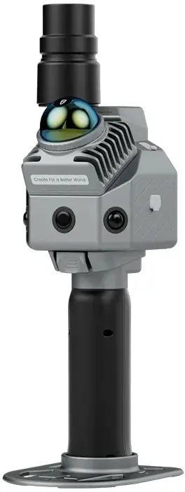
FJD Trion™ P2 LiDAR Scanner
Go-anywhere Scanning
Next-Generation Portable Design, Industrial-Grade Accuracy
Weighing just 700g, the FJD Trion P2 LiDAR Scanner delivers centimeter-level precision, real-time colorized point clouds, and multi-format outputs. Its field-ready design lets professionals capture complex landscapes and intricate details with ease.
Multi-SLAM Fusion, Robust Performance
Eliminate drift with hybrid constraints, even in featureless areas like beaches, tunnels, and parks.
HyperDense+
With the HyperDense+ feature in the FJD Trion Model, it delivers 5-7x denser clouds, giving you better colorization and overall quality.
Real-Time True-Color Point Clouds, Build-in Camera, Upgrade CPU
Capture motion without blur with a 2MP global shutter, and record high detail textures using dual 12MP RGB cameras.
Real-time on-device CPU processing delivers colorized point clouds once the scan is complete.
One Scan, Multiple Deliverables
Maximize efficiency with multi-format deliverables from a single scan:
Designed to Work Together
Capture, process, and deliver your 3D data within one connected FJD Trion workflow.
Data collection
FJD Trion Scan : App based real time control and scan file management.
Data processing
FJD Trion Model : Generate reports for construction, forestry, mining, and more
Generate Deliverables
FJD Trion Model for Tablets : On site post processing and preview with iPad and Android support
Cloud Collaboration
FJD Trion Model : Share data online and collaborate with your team using different tools
FJD Trion™ P2 Specifications
LiDAR
- Speed 200,000 pts/s
- Field of View 360° × 59°
- Scanning Range 40 m @ 10% reflectivity / 70 m @ 80% reflectivity
- Laser Wavelength 905 nm
- Safety Level Eye-safety Class I
- Point Cloud Processing Real-time processing
- Point Cloud DisplayReal-time point cloud preview
- Continue Scanning ✓
- Hyperdense+ ✓
Accuracy
- Real-Time Point Cloud Accuracy Relative: 2 cm / Absolute: 5 cm
- Post-Processed Point Cloud Accuracy Relative: 1.2 cm / Absolute: 3 cm
Build-in Camera
- FOV (Front Camera) 70°
- FOV (Side Camera)280°×149°
- Resolution (Front Camera)2 MP
- Resolution (Side Camera)2 x 12 MP
- Visual SLAM ✓
- Image Export ✓
- Image Format .jpg
- External Camera Insta360 X5
System Parameters
- Dimensions 110×106×280 mm
- Weight 700 g (excluding battery, external camera and GNSS module) / 1200 g (including battery and GNSS module) / 1500 g (including battery, external camera and GNSS module)
- Storage 512G (1TB expandable)
- Operating Temperature -20℃ - 50℃
- Storage Temperature -40℃ - 60℃
- Ingress Protection IP 54
- Data Export Wireless Network , USB Type-C, USB Flash Disk
- Point Cloud Format .las / .ply / .pts / .e57
Electrical Specifications
- Battery Life 4H (with 1 set of 2 batteries, including GNSS module, exclude external camera) / 3H (with 1 set of 2 batteries, including GNSS module and external camera)
- Power Supply DC Handheld Battery
- Power Consumption 15 W (exclude external camera) / 21 W (include external camera)
- Charger 67W Fast Charging
- Simultaneous Dual-Battery Charging ✓
GNSS
- Satellite Constellation BDS (B1I / B2I / B3I / B1C / B2a / B2b) / GPS (L1 C/A / L1C / L2P (Y) / L2C / L5) / GLONASS (G1 / G2 / G3) / Galileo (E1 / E5a / E5b / E6) / QZSS (L1C/A / L1C / L2C / L5) / IRNSS and SBAS support by a firmware upgrade
- RTK Accuracy H: 8 mm + 1 ppm RMS / V: 15 mm + 1 ppm RMS
- Positioning Rate 10 Hz
- PPK ✓